Engineer Cites Benefits of $6B Texas Storm Surge Protection Proposal
We’re looking at much more intense storms than [the Corps].
This article originally appeared on Engineering News Record’s website.
Key Takeaways- The proposal, unveiled in 2015, calls for a gate structure similar to one on the Maeslant Barrier in Rotterdam, Holland, which will span the channel.
- The National Oceanic and Atmospheric Administration predicts sea levels will rise 10 in. to 12 in. by 2050, creating a massive shift in coastal flooding over the next 25 years.
- The Galveston Bay Park Plan would allow more development flexibility than the Corps’ plan to combat rising water levels.
Overview
It’s not if, but when, a Category 5 hurricane crashes into Galveston Bay in Texas causing billions in destruction, possibly stopping 14% of U.S. crude oil refining and affecting five million people, according to Walter P Moore and Associates and Rice University.
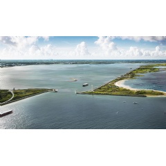
The engineer and the school, both based in Houston, are involved in the Galveston Bay Park Plan. It calls for construction of a 22-mile chain of islands, at a cost of about $6 billion to serve as a storm surge barrier to protect the Houston Ship Channel and west side of Galveston Bay.
“We’re looking at much more intense storms than [the Corps]. We’re trying to identify [areas] that are beneficial that the Corps cannot necessarily utilize in its calculations.”
The barrier would also provide everyday benefits that would improve the bay area habitat and water quality and provide needed and rare public accessibility for recreation, says Charlie Penland, Walter P Moore managing principal for infrastructure. The firm is working with the university’s Severe Storm Prediction, Education and Evacuation from Disasters Center.
The proposal, unveiled in 2015, calls for a gate structure similar to one on the Maeslant Barrier in Rotterdam, Holland, which will span the channel, Penland says. Additionally, there would five other gates along the barrier where existing channels will allow for the passage of recreational craft and drainage.
The project is part of an overall Galveston Bay plan that includes the Coastal Spine barrier project that the U.S. Army Corps of Engineers is now moving through the environmental impact study phase, The seaside barrier would be along Galveston Island and Bolivar Peninsula, Walter P Moore said in an email.
“Compatible with [that], Galveston Bay Park Plan will replace the planned improvements along the west side of the bay, saving [it] an estimated $2 billion and eliminating the impact on private and commercial properties that are part of the [Corps] plan,” the statement said.
Proposal work has been funded by various entities, including Houston, Harris County and the Port of Houston. In February, plan leaders met with officials of the state General Land Office, which is responsible for public land usage, and are preparing to apply for an environmental permit in the coming year.
Sea Levels
According to the National Oceanic and Atmospheric Administration’s 2022 Sea Level Rise Technical Report, sea levels are forecasted to rise 10 in. to 12 in. by 2050, creating a massive shift in coastal flooding over the next 25 years. Another study by Tulane University estimates that sea levels along the U.S. Southeast and Gulf coasts have risen at “record-breaking rates” over the last dozen years—approximately 0.05 in. per year since 2010. Sea Level Rise.org predictions also show sea levels rising between 12 in. and 27 in. from 2016 to 2050.
The next Category 5 storm in the area could take a toll financially on the global economy, says Penland.
Ten refineries are located in the Houston area, refining about 14% of U.S. crude oil production or 2.6 million barrels per day. The top three oil producers refine more than 1.6 million barrels per day.
“Anything that hits these complexes would be devastating from a national security standpoint,” adds Penland. “The whole financial world would be negatively impacted.”
While still preparing for environmental studies, Penland says the Galveston Bay Park Plan would allow more development flexibility than the Corps’ plan to combat rising water levels.
“Because the plan comes from the [university], it’s not tied to specific guidelines of studies the Corps of Engineers has to follow … giving us a little more leniency in what we can consider,” says Penland. “So, we’re looking at much more intense storms than [the Corps]. We’re trying to identify [areas] that are beneficial that the Corps cannot necessarily utilize in its calculations.”
The Corps has “very tight” guidelines on what it can build, including its cost-benefit analysis and government statistics on flooding, Penland adds.
Currently, the project is being evaluated to determine if it should be part of the Texas Coastal Surge Protection Plan or otherwise funded locally.
The goal is for the groundbreaking in 2030, at the latest.
( Press Release Image: https://photos.webwire.com/prmedia/7/319935/319935-1.jpg )
WebWireID319935
This news content was configured by WebWire editorial staff. Linking is permitted.
News Release Distribution and Press Release Distribution Services Provided by WebWire.
